


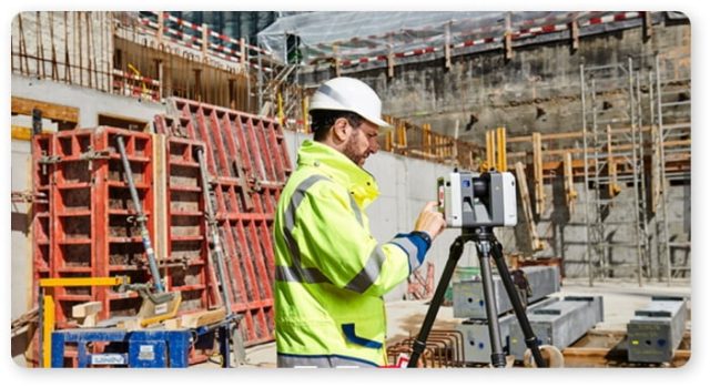
Ground 3D laser scanning
Laser scanning is an advanced non-contact technology for three-dimensional measurement of objects and surfaces. Compared to traditional optical and satellite geodetic methods, laser scanning technology is characterized by phenomenal detail, incredible speed, and high measurement accuracy. This technology is truly revolutionary in the field of engineering surveys, since it was its appearance that predetermined a powerful qualitative breakthrough in the entire industry. Today, laser scanning is widely used in architecture, industry and energy, geodesy and surveying, on objects of transport infrastructure, in civil and industrial construction, mining, archeology, it is also in demand in many other manufacturing and national industries. MCI specialists have the highest profile geodetic education and valid qualification certificates confirming the level of knowledge.
All this in combination with the latest fleet of modern geodetic equipment allows us to perform work with the highest quality.
We can execute:
1. Scanning of buildings / structures, premises of industrial and civil construction.
Before proceeding with the reconstruction of any object, the best option would be to obtain voluminous and specific information about this object in digital form. During scanning, dimensions, dimensions, position in space, supporting structures, etc. are transmitted. Thus, time is saved for the study of the object and, accordingly, funds. Measurement of buildings and rooms may be needed for digital analysis, where accurate data on physical elements is required to accurately determine compliance with the required technical settings. With 3D models of buildings, you can create archival databases of obsolete elements in the form of digital data.
Digital archiving can replace all previously stored schemes, drawings, documentation in paper form or even electronic, thanks to the creation of just a digital model of the object itself.

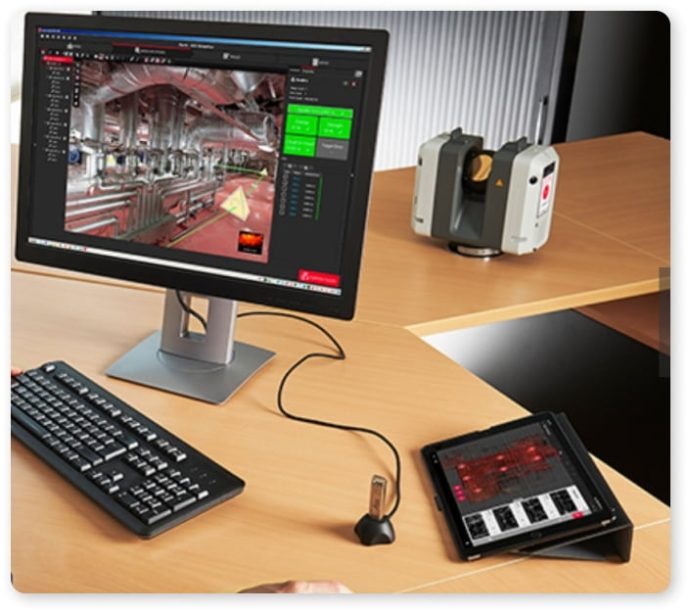
2. Processing point clouds.
3. Quality control of production and construction in industrial and civil engineering using 3D scanning.
A significant part of enterprises is in need of deep modernization, however, the lack of initial and / or relevant executive documentation, schemes and plans significantly complicates the work at the stage of creating a modernization project. 3D terrestrial laser scanning can dramatically reduce the cost of creating accurate and up-to-date information about the enterprise.
Active modernization and construction of new production facilities have shown the effectiveness of 3D laser scanning technology in the process of quality control and scope of work performed by contractors. Ground-based laser scanning allows you to quickly determine the actual dimensions and position of building structures and equipment to be installed, superimpose the measurement results on the design model of the object and determine their deviations from the design values.
 4. Control of geometry changes during the operation of industrial and civil construction using 3D scanning.
Control over the change in the shape and size of the object due to design features, the action of loads and temperature and climatic effects, as well as changing the position of the object relative to the original.
5. Carrying out three-dimensional scanning and panoramic photography in the information modeling of operating objects.
6. Definition of volumes of technological capacities, earthwork.
7. Determination of volumes of bulk materials and inventory of raw materials using 3D laser scanning.
8. Determination of horizontal / vertical deviations (roll) and the degree of deflection of structural elements, identification of structural defects.
9. Control over deformations of both existing and under construction structures for monitoring purposes.
10. High-precision digitizing of structures, parts, mechanisms during acceptance, troubleshooting. Scan data is measurement information, and you can use it to measure the actual distances between any points or elements of the scanned object.
11. Carrying out high-precision digitizing and panoramic photography of structures, parts, mechanisms, transport in case of damage, accidents, to assess the damage caused, or to calculate the funds required for restoration.
12. Carrying out high-precision digitizing and panoramic photography to recreate spare parts for equipment out of production.